.JPG) |
| The landscape opens a bit as we near Washington, D.C. |
Friday, September 27, 40 miles.
We savored the last miles of our trip. It was a self-imposed slowness that was unspoken; neither of us had agreed to slacken the pace. I felt bittersweet; it was an incredible journey that was coming to a close, yet I hungered for more riding. The forecast promised an incredible stretch of fine weather, and though I'm not one to revisit an adventure—too many places to see, so little time—I finally understood why people have ridden this trail numerous times: we missed Antietam Battlefield and other sights. All things aside, I could've turned around and ridden back to Pittsburgh.
.jpg) |
| Broad Run Trunk Aqueduct kept in working order. Photo credit: Patty |
It was easy to stall the inevitable entry into a big city. Again, we flushed a barred owl from the trail; we stopped to gawk at egrets or listen to Canadian geese emit an eerie sky-filled shrill that almost made me cover my head, and since we couldn't spy the flock through dense canopy, I wondered at their numbers flying overhead or perhaps congregating a stone's throw away along the Potomac. And, like many days herons and turtles were constant companions, ornamenting a disused canal.
But when we arrived at Great Falls Tavern a working canal boat, led by mules, displayed the former C&O work life like nothing else could.
We got to see the speed at which the mules walked, how important a taught towline was to overall tracking and navigation, and surprisingly—at least to me—that two people, and not one, directed the mules.
.jpg) |
| Photo credit: Patty |
Nearby, we took turns investigating a long elevated walkway for precious views of Great Falls. It's a magical place, if not wholly natural because of an upriver dam. Near golden trees and debris deposited at high water line illustrates a tumultuous environment. The falls are in constant flux, influenced by season and rainfall, and I imagine, a wonder that draws people back, again and again.
.jpg) |
| Photo credit: Patty |
.jpg) |
| Annie crossing towpath at Widewater. Photo credit: Patty |
Downriver, hiking trails veered off into the woods, eventually looping back. There were walkers, something we didn't see a lot of in earlier days.
.jpg) |
| Photo credit: Patty |
Lo and behold a snake eases onto the path. And not just any snake, but a 5-foot all black thing with white-checked belly.
.jpg) |
| Photo credit: Patty |
We keep our distance and watch it meander away, disappearing into grass beside the canal. I later learned that sometimes snakes coil themselves around a tree trunk. Not for the first time I was thankful we cycled in Autumn, when creatures, great and small, are often languid or non-existent, especially snakes and mosquitoes.
.jpg) |
| We take lots of pictures, having to leapfrog a runner a few times. |
With three miles to the finish line, a paved trail appeared. It would be easier to cycle on asphalt, but we didn't come all the way from Pittsburgh, riding every trail mile to bypass a bit of discomfort at the end. Instead, we stuck to the plan, even though the dirt trail had become much rougher since leaving Great Falls.
.JPG) |
| Mile marker 1. Photo credit: Patty |
With one mile to go, Georgetown's brick buildings considerably narrow the C&O Canal National Park. On paper, and in reality, it felt like entering D.C. through the back door.
Following the canal to it's source, becomes an interesting game in navigating city infrastructure. Bridges and roadways now block what was once a continuous towpath. It's unclear where to go; not even the guide book is a help. However, strangers point us in the right direction.
There's nothing quite like hefting touring loads up and down stairs. I'm glad we only had to do it once.
.JPG) |
| Narrow section in Georgetown. |
A short jaunt brings us to a busy street, one blocked by barricades and numerous policemen. Fortunately, they let us through.
.jpg) |
| Historical park sign. Photo credit: Patty |
The C&O Canal pathway is brick-lined between one city block. A former tourist canal boat is left to rot in the water, sadly full of peeling paint and dirt.
.JPG) |
| The canal's humble beginning. |
Directions are sketchy at the end and we nearly get separated. But Patty finds the way, past a marina. I never would have guessed we'd need to duck between long skulls on shore and a boat house. But there, on the other side is the canal and it's intersection with the Potomac.
.jpg) |
| Cement post marks canal entrance. |
335 miles later we are at mile marker 0.
.jpg) |
| Photo credit: Patty |
.JPG) |
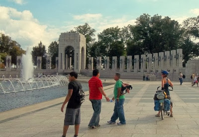
| World War II Memorial. |
It's such a nice day and only two o'clock. It seems a shame to retreat to a hotel on the far side of the river when D.C.'s monuments are so close. We join the throngs around the Lincoln, WWII, and Korean memorials, pushing bikes when appropriate.
.jpg) |
| Reflecting pool and scaffold-wrapped Washington Monument in background. Photo credit: Patty |
.jpg) |
| I could've ridden the entire Mount Vernon Trail. It's great being in touring shape again. Photo credit: Patty |
The it's off to Reagan National Airport to retrieve our car, via the Mount Vernon Trail.
.JPG) |
| At the end of the runway, Andy must watch a plane zoom overhead |
Taking care of bikes, hotel, and much needed showers, we relax and reminisce over margaritas and Mexican food. What a great adventure!
.JPG)
.jpg)

.jpg)
.jpg)
.jpg)
.jpg)
.jpg)
.jpg)
.jpg)
.JPG)
.JPG)
.jpg)
.JPG)
.jpg)
.JPG)
.jpg)
.jpg)
.JPG)
.jpg)
.jpg)
.JPG)
I found your blog through Mary G. I love the GAPCO adventure. I hope to make it there someday. Jo
ReplyDeleteHi Jolene. Nice to have another bike blog to follow. That's a great write-up of your coffeeneuring challenge. I recognized the Beanery. Is that the one in Corvallis? I've spent sometime there. We ended our Cross Country ride in Corvallis, then lived in Portland form 1985-1986.
Delete